Remote sensing is a powerful technology that enables the collection of information about an object or area from a distance, typically using satellite or aerial sensor technologies. This method of data acquisition has revolutionized the way scientists, researchers, and policymakers understand and manage the Earth’s resources. By capturing data across various wavelengths of the electromagnetic spectrum, remote sensing provides insights into land use, vegetation cover, water bodies, and even atmospheric conditions.
The ability to gather large-scale data efficiently and effectively has made remote sensing an indispensable tool in numerous fields, particularly in environmental monitoring and management. The evolution of remote sensing can be traced back to the early 20th century when aerial photography began to be used for mapping and reconnaissance. However, it was not until the advent of satellite technology in the 1960s that remote sensing truly began to flourish.
The launch of the first Earth-observing satellite, Landsat 1, in 1972 marked a significant milestone in this field. Since then, advancements in sensor technology, data processing capabilities, and analytical techniques have expanded the scope and accuracy of remote sensing applications. Today, remote sensing encompasses a wide range of technologies, including passive and active sensors, multispectral and hyperspectral imaging, and radar systems, each contributing unique capabilities to environmental data collection.
Key Takeaways
- Remote sensing is the process of collecting and analyzing information about an object without being in direct physical contact with it.
- There are various types of remote sensing technologies, including aerial photography, satellite imaging, and LiDAR, each with its own unique capabilities and applications.
- Remote sensing is widely used in environmental data collection for purposes such as monitoring land use changes, assessing natural disasters, and studying climate patterns.
- The advantages of remote sensing in environmental data collection include its ability to cover large areas, its cost-effectiveness, and its ability to provide data over time for trend analysis.
- However, remote sensing also has limitations and challenges, such as limited spatial resolution, atmospheric interference, and the need for specialized training to interpret data accurately.
Types of Remote Sensing Technologies
Remote sensing technologies can be broadly categorized into two main types: passive and active sensors. Passive remote sensing relies on natural energy sources, primarily sunlight, to capture data. Sensors in this category detect reflected or emitted radiation from the Earth’s surface.
For instance, multispectral sensors on satellites like Landsat capture images in various spectral bands, allowing for the analysis of vegetation health, soil moisture, and land cover changes. These sensors are particularly effective for applications such as agricultural monitoring and forest management, where variations in reflectance can indicate changes in plant health or land use. In contrast, active remote sensing involves the emission of energy towards the Earth’s surface and measuring the reflected signals.
Radar and LiDAR (Light Detection and Ranging) are prominent examples of active remote sensing technologies. Radar systems emit microwave signals that can penetrate cloud cover and provide valuable information about surface topography and land cover. LiDAR uses laser pulses to measure distances with high precision, enabling detailed three-dimensional mapping of vegetation structure and terrain.
This technology is particularly useful in forestry applications where understanding canopy height and density is crucial for assessing biomass and carbon storage.
Applications of Remote Sensing in Environmental Data Collection

The applications of remote sensing in environmental data collection are vast and varied, spanning multiple disciplines such as ecology, geology, hydrology, and urban planning. One significant application is in monitoring deforestation and land-use change. Satellite imagery allows researchers to track changes in forest cover over time, providing critical data for conservation efforts and policy-making.
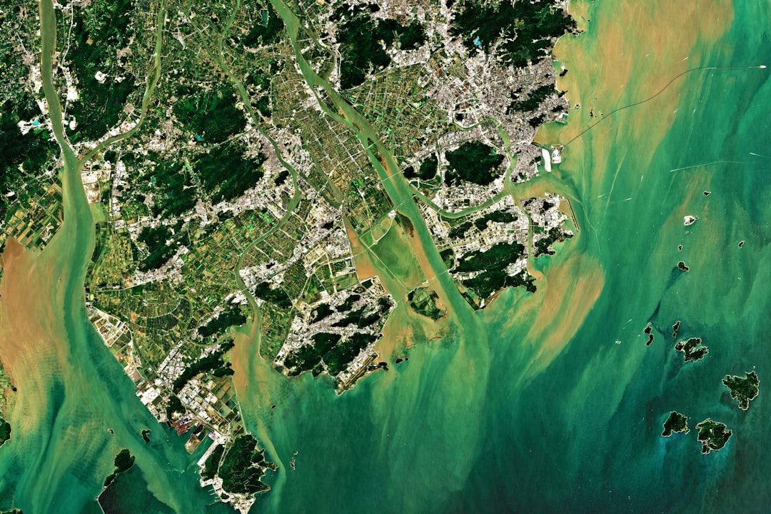
For example, the Global Forest Watch initiative utilizes satellite data to monitor forest loss in near real-time, enabling stakeholders to respond swiftly to illegal logging activities or natural disasters. Another important application is in water resource management. Remote sensing technologies can assess water quality, monitor surface water levels, and track changes in wetland areas.
For instance, the European Space Agency’s Sentinel-2 satellites provide high-resolution imagery that can be used to monitor algal blooms in lakes and coastal waters. By analyzing spectral data, scientists can identify changes in chlorophyll concentrations that indicate shifts in water quality due to nutrient runoff or pollution. This information is vital for managing aquatic ecosystems and ensuring sustainable water resources.
Advantages of Remote Sensing in Environmental Data Collection
One of the primary advantages of remote sensing is its ability to collect data over large geographic areas quickly and efficiently. Traditional ground-based methods of data collection can be time-consuming and labor-intensive, often limited by accessibility issues or logistical constraints. In contrast, remote sensing allows for comprehensive coverage of vast regions without the need for extensive fieldwork.
This capability is particularly beneficial for monitoring environmental changes over time, as it enables researchers to analyze trends and patterns on a global scale. Additionally, remote sensing provides a wealth of data that can be integrated with geographic information systems (GIS) for advanced spatial analysis. The combination of remote sensing data with GIS allows for sophisticated modeling and visualization techniques that enhance decision-making processes.
For example, urban planners can use remote sensing data to assess land use patterns and predict future growth scenarios, facilitating more informed planning decisions that consider environmental impacts. Furthermore, the ability to access historical satellite imagery enables researchers to conduct long-term studies on climate change effects or habitat loss.
Challenges and Limitations of Remote Sensing in Environmental Data Collection
Despite its numerous advantages, remote sensing also faces several challenges and limitations that can impact its effectiveness in environmental data collection. One significant challenge is the issue of data resolution. While satellite imagery can cover large areas, the spatial resolution may not always be sufficient for certain applications that require detailed information at a finer scale.
For instance, monitoring small-scale agricultural practices or localized pollution sources may necessitate higher-resolution imagery than what is typically available from standard satellite platforms. Another limitation is related to atmospheric interference and sensor calibration. Factors such as cloud cover, haze, and variations in atmospheric conditions can affect the quality of remotely sensed data.
For example, optical sensors may struggle to capture clear images during overcast weather or when smoke from wildfires obscures visibility.
Future Trends in Remote Sensing for Environmental Data Collection

Small Satellites Revolutionize Earth Observation
One notable trend is the increasing use of small satellites or CubeSats for Earth observation. These miniaturized satellites are cost-effective and can be deployed in large constellations to provide high-frequency data collection over specific areas.
Enhancing Data Analysis with Machine Learning and AI
Moreover, advancements in machine learning and artificial intelligence are poised to enhance the analysis of remote sensing data significantly. By leveraging these technologies, researchers can automate the classification of land cover types or detect changes more efficiently than traditional methods allow.
Towards More Accurate Predictions and Improved Management
For instance, deep learning algorithms can analyze vast datasets from multiple sensors to identify patterns that may not be immediately apparent through manual interpretation. This integration of AI with remote sensing will likely lead to more accurate predictions regarding environmental changes and improved management strategies.
Case Studies of Remote Sensing in Environmental Data Collection
Several case studies illustrate the impactful role of remote sensing in environmental data collection across various contexts. One prominent example is the use of remote sensing to monitor coral reef health in the Great Barrier Reef. Researchers have employed satellite imagery to assess coral bleaching events by analyzing changes in reflectance associated with stressed corals.
This approach has enabled timely assessments of reef conditions following climate-related disturbances, informing conservation efforts aimed at protecting these vital ecosystems. Another compelling case study involves the application of remote sensing in tracking land subsidence in urban areas such as Mexico City. Utilizing synthetic aperture radar (SAR) technology, scientists have been able to detect minute ground movements caused by factors such as groundwater extraction and geological instability.
By mapping these subsidence patterns over time, urban planners can develop strategies to mitigate risks associated with infrastructure damage and ensure sustainable urban development.
Conclusion and Recommendations for Remote Sensing in Environmental Data Collection
As remote sensing continues to evolve, it is essential for stakeholders involved in environmental management to embrace its potential while addressing its limitations. Collaboration between scientists, policymakers, and technology developers will be crucial in maximizing the benefits of remote sensing for environmental data collection. Investing in training programs that enhance technical skills related to remote sensing analysis will empower researchers to leverage these tools effectively.
Furthermore, fostering open access to remote sensing data will facilitate broader participation in environmental monitoring efforts. Initiatives that promote data sharing among governments, research institutions, and non-governmental organizations can enhance collective understanding of environmental issues on a global scale. By harnessing the power of remote sensing alongside traditional methods of data collection, we can develop more comprehensive strategies for addressing pressing environmental challenges while ensuring sustainable resource management for future generations.
This software can aid in translating research findings and reports into multiple languages, making them accessible to a wider audience. For more information on the best free software for translation, check out this article.
FAQs
What is remote sensing?
Remote sensing is the process of collecting data about an object or area from a distance, typically using satellites or aircraft equipped with sensors.
How is remote sensing used in environmental data collection?
Remote sensing is used to gather information about the Earth’s surface and atmosphere, including land use, vegetation cover, water quality, and air pollution. This data is crucial for monitoring and managing environmental resources.
What are the benefits of using remote sensing for environmental data collection?
Remote sensing allows for large-scale and repetitive data collection, providing a comprehensive and up-to-date understanding of environmental changes. It also enables monitoring of remote or inaccessible areas.
What types of sensors are used in remote sensing for environmental data collection?
Sensors used in remote sensing include optical sensors (for visible and infrared light), thermal sensors (for heat radiation), and radar sensors (for detecting surface features using radio waves).
What are some examples of environmental applications of remote sensing data?
Examples of environmental applications include monitoring deforestation, assessing crop health, tracking changes in sea ice extent, and detecting urban heat islands. Remote sensing data is also used in disaster management and climate change research.
How does remote sensing contribute to environmental conservation and management?
Remote sensing data provides valuable information for making informed decisions about natural resource management, land use planning, and environmental protection. It also supports efforts to monitor and mitigate the impacts of human activities on the environment.