So, how is all this tech helping us get a handle on wildfires before they get out of control? In a nutshell, technology is transforming wildfire prevention and early detection by offering earlier alerts, more precise monitoring, and better-informed decision-making. Instead of relying solely on eyes from watchtowers or the infrequent flight, we’re now leveraging a sophisticated network of sensors, drones, AI, and even satellites to spot potential fires in their infancy and understand the risks involved. Think of it as giving firefighters and land managers a super-powered magnifying glass and an early warning system all rolled into one.
It’s no longer just about looking out for smoke. Technology is deploying a whole army of sensors right on the ground, diligently keeping watch. These are often placed in areas known to be high-risk and can detect subtle changes that might signal trouble long before a visible flame appears.
Thermal Imaging Sensors
These aren’t your average temperature gauges. Thermal sensors are designed to pick up on heat signatures, even faint ones. They can detect smoldering embers or early stages of combustion that are invisible to the naked eye. By identifying these “hot spots,” they can alert authorities to a potential ignition source that might otherwise go unnoticed until it flares up. This is crucial for detecting fires in dense undergrowth or at night, when visual detection is significantly hampered.
Smoke Particle Detectors
Similar to how smoke detectors work in our homes, but on a much larger scale and with far greater sensitivity. These devices can identify specific chemical compounds or concentrations of particulate matter that are characteristic of burning vegetation. They can differentiate between smoke and other atmospheric conditions, reducing false alarms.
Air Quality Monitoring
Beyond just detecting smoke, some sensors monitor a range of air quality parameters. Sudden shifts in things like carbon monoxide, carbon dioxide, or specific volatile organic compounds can indicate combustion. This provides a broader picture and can be an early indicator of a smoldering fire before smoke becomes visually apparent.
IoT Connectivity for Real-Time Data
The real power of these ground sensors comes from their ability to communicate in real-time. They’re often part of an interconnected network using the Internet of Things (IoT). This means that as soon as a sensor detects an anomaly, that data is immediately transmitted to a central command center or directly to the phones of relevant personnel. This allows for an incredibly rapid response, potentially reaching a fire when it’s just a few square feet, not acres.
In addition to exploring how technology is assisting in wildfire prevention and early detection, it is interesting to consider the broader implications of tech in various fields, such as health management. A related article discusses the best Android health management watches, highlighting how wearable technology can monitor vital signs and promote wellness. For more information, you can read the article here: Best Android Health Management Watches.
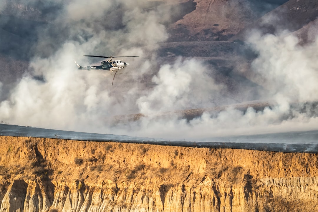
Eyes from Above: Drones and Cameras
While ground sensors are our tireless sentinels, sometimes you need to get a broader perspective. That’s where drones and advanced camera systems are coming into play, offering a dynamic and flexible way to survey vast areas.
Drone-Based Surveillance
Drones, or Unmanned Aerial Vehicles (UAVs), are becoming indispensable tools. They can be equipped with a variety of sensors, including high-resolution visible-light cameras, thermal cameras, and even gas sensors. This allows for targeted patrols over vulnerable areas, responding to sensor alerts, or conducting broad surveys.
Rapid Response and Reconnaissance
When a potential fire is detected, drones can be launched quickly to get eyes on the situation. They can provide real-time video feeds, helping firefighters assess the size, intensity, and direction of the fire, as well as identifying any potential hazards or access issues. This information is critical for strategizing an effective response.
Thermal Mapping and hotspots identification
Drones equipped with thermal cameras are particularly valuable. They can create detailed thermal maps of an area, highlighting hot spots that might not be visible otherwise. This is crucial for detecting underground fires, smoldering material, or the re-emergence of hotspots after a fire has apparently been extinguished.
Fixed Camera Networks
In high-risk regions, strategically placed camera networks are becoming more common. These are often high-resolution, pan-tilt-zoom (PTZ) cameras that can cover extensive landscapes. Some are even equipped with AI capabilities for automated smoke detection.
AI-Powered Visual Analysis
This is where the magic happens. Instead of a human constantly watching hundreds of camera feeds, AI algorithms are trained to scan the footage for visual cues of smoke. They can differentiate between smoke, mist, fog, and dust with increasing accuracy, significantly reducing false alarms while ensuring no actual smoke is missed. Think of it as having thousands of virtual lookouts working 24/7.
Day and Night Vigilance
Many fixed camera systems are equipped with infrared capabilities, allowing them to operate effectively both day and night. This provides continuous monitoring, a significant advantage over relying solely on visual patrols that are limited by daylight hours.
The Power of Prediction: AI and Machine Learning

Beyond just spotting fires, technology is helping us anticipate where and when they’re most likely to occur. This proactive approach is a game-changer for prevention.
Predictive Modeling
Artificial intelligence (AI) and machine learning (ML) are being used to develop sophisticated predictive models. These models analyze a vast array of data, including historical fire data, weather patterns, vegetation moisture content, topography, and even human activity.
Weather Forecasting Integration
Precise, localized weather forecasts are a cornerstone of wildfire prediction. AI models integrate real-time and forecasted weather data, such as temperature, humidity, wind speed and direction, and lightning strikes. This helps identify periods of high fire danger.
Vegetation Analysis and Fuel Load Mapping
AI can analyze satellite imagery and aerial data to map vegetation types and estimate their moisture content and density. This “fuel load” mapping helps identify areas where fire could spread rapidly. Understanding the type and condition of vegetation is critical for predicting fire behavior.
Human Activity Patterns
In some cases, AI can even analyze data related to human activity, such as camping permits, road traffic, or energy infrastructure activity, to identify areas with a higher risk of human-caused ignitions. This can inform where to focus preventative measures and patrols.
Risk Assessment and Early Warning Systems
By combining these predictive capabilities, AI can generate detailed risk assessments that highlight areas with the highest probability of ignitions and rapid fire spread. These assessments can then be translated into early warning systems.
Dynamic Risk Mapping
These aren’t static maps. They are dynamic, updating in near real-time as conditions change. This allows resource managers to allocate preventative measures, such as increased patrols, prescribed burns, or public awareness campaigns, to the areas that need them most.
Targeted Alerts
Instead of generalized warnings, technology can enable more targeted alerts. If a specific canyon is showing a high risk of ignition due to a combination of dry vegetation and a forecast for strong winds, authorities can issue localized warnings or dispatch resources proactively.
Satellites: The Global Overview

For a broad and consistent view, satellites are an invaluable asset in both prevention and early detection of wildfires, offering a perspective that ground-based or aerial systems simply can’t match.
Wide-Area Monitoring
Satellites provide a continuous, synoptic view of vast geographical areas. This is crucial for monitoring national parks, vast forest lands, and remote regions where ground patrols or frequent aerial surveys are impractical or cost-prohibitive.
Thermal Anomaly Detection
Many Earth-observation satellites are equipped with infrared sensors capable of detecting thermal anomalies. These anomalies can indicate areas of unusual heat, which is a strong indicator of an ongoing fire, even if it’s not yet producing visible smoke.
Early Smoke Plume Identification
Even beyond thermal signatures, advanced satellite sensors can sometimes detect the very faint chemical signatures or particulate matter associated with smoke plumes as they begin to form. This allows for detection before a fire is visually apparent from the ground or even from lower-altitude aircraft.
Fire Mapping and Footprint Analysis
Once a wildfire is detected, satellites can map its extent and growth with remarkable accuracy. This data is critical for incident management, helping fire crews understand the scale of the problem and plan their containment strategies.
Burn Scar Mapping
After a fire has been extinguished, satellites can map the extent of the burn scar. This information is vital for post-fire recovery efforts, understanding ecological impact, and informing future land management decisions.
Near Real-Time Data Dissemination
With advancements in satellite technology, data can often be processed and disseminated in near real-time. This means that fire managers can receive up-to-date information on fire location and spread, allowing for more agile and effective response.
In recent years, technology has played a crucial role in enhancing wildfire prevention and early detection efforts, as detailed in a related article that explores innovative solutions. For instance, advancements in satellite imagery and AI-driven analytics are enabling quicker responses to potential fire outbreaks. If you’re interested in learning more about how technology is evolving in various fields, you might find this article on the features of the Samsung Galaxy Chromebook 2 insightful. You can read it here.
Enhancing Response and Strategy: Connecting the Dots
| Technology | Application |
|---|---|
| Satellite Imaging | Provides real-time monitoring of forest areas for early detection of wildfires |
| Drones | Used for aerial surveillance and monitoring of remote areas to detect wildfires |
| IoT Sensors | Deployed in forests to detect changes in temperature, humidity, and smoke levels |
| Machine Learning | Analyzes historical data to predict wildfire risk and potential ignition sources |
| Mobile Apps | Allow citizens to report potential fire hazards and receive alerts about nearby wildfires |
Ultimately, all this technology is about more than just seeing a fire. It’s about empowering those on the front lines with the knowledge and tools they need to respond effectively and make smarter decisions.
Integrated Command Centers
Technology is enabling the development of sophisticated, integrated command centers. These centers pull in data from all sources – sensors, drones, cameras, satellites, weather stations, and predictive models – into a single, unified dashboard.
Situational Awareness Platforms
These platforms provide a comprehensive, real-time view of the entire situation. Fire managers can see where fires are burning, their intensity, the predicted spread, available resources, and the status of those resources, all in one place. This drastically improves situational awareness and reduces the chance of crucial information being missed.
Resource Allocation Optimization
With better data and a clearer picture of the fire’s behavior and risk areas, authorities can optimize the allocation of resources. This means sending the right equipment and personnel to the right place at the right time, making the response more efficient and effective.
Communication and Coordination Tools
Technology provides enhanced communication channels between different fire agencies, government bodies, and even the public.
Mobile Applications for Field Crews
Field crews can be equipped with mobile apps that receive real-time updates, incident information, and can even transmit their location and status back to command. This seamless communication is vital for coordinating complex operations.
Public Alert Systems
Technology facilitates more effective public alert systems. By understanding where a fire is moving and the potential risks, authorities can issue timely and targeted evacuation warnings or advisories through various channels, including mobile alerts and social media.
Post-Fire Analysis and Learning
The data collected by these technologies also fuels invaluable post-fire analysis. This data is used to refine predictive models, improve prevention strategies, and learn from past incidents to better prepare for future wildfire seasons. It creates a feedback loop that continuously enhances our ability to manage wildfire risk.
FAQs
What is the role of technology in wildfire prevention and early detection?
Technology plays a crucial role in wildfire prevention and early detection by providing tools such as satellite imaging, drones, and advanced sensors to monitor and detect potential wildfire risks. These technologies help in identifying and monitoring fire-prone areas, allowing for early intervention and prevention measures.
How do satellite imaging and drones assist in wildfire prevention?
Satellite imaging and drones are used to monitor large areas of land for signs of potential wildfires. They can detect changes in vegetation, temperature, and humidity, providing valuable data for early detection and prevention efforts. Drones can also be used to assess the extent of a wildfire and plan firefighting strategies.
What role do advanced sensors play in wildfire prevention and early detection?
Advanced sensors are used to monitor environmental conditions such as temperature, humidity, and wind speed, which are critical factors in assessing wildfire risk. These sensors can provide real-time data to alert authorities to potential fire hazards, allowing for prompt action to prevent wildfires from spreading.
How is artificial intelligence (AI) being utilized in wildfire prevention and early detection?
Artificial intelligence is being used to analyze vast amounts of data collected from various sources, such as satellite imaging and sensors, to identify patterns and trends that may indicate potential wildfire risks. AI can also help in predicting the behavior of wildfires and optimizing firefighting strategies.
What are some examples of tech companies and organizations involved in wildfire prevention and early detection efforts?
Tech companies such as Google, Microsoft, and IBM, as well as organizations like the National Aeronautics and Space Administration (NASA) and the National Oceanic and Atmospheric Administration (NOAA), are actively involved in developing and deploying technology for wildfire prevention and early detection. These entities are leveraging their expertise in data analysis, remote sensing, and AI to support efforts to mitigate the impact of wildfires.