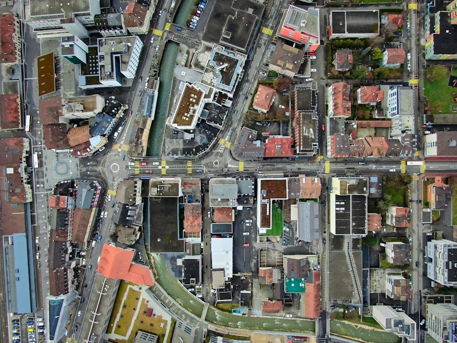
The advent of drone technology has revolutionized various sectors, and urban planning is no exception.
Their ability to capture high-resolution aerial imagery and collect data from hard-to-reach areas has made them indispensable in the toolkit of urban planners.
As cities continue to grow and evolve, the integration of drones into urban planning practices offers innovative solutions to complex challenges, enabling planners to visualize and analyze urban environments in unprecedented ways. Urban planning involves a multitude of tasks, from land use analysis to infrastructure development, all of which require comprehensive data collection and analysis. Traditional methods often involve extensive fieldwork, which can be time-consuming and costly.
Drones streamline this process by providing real-time data and imagery, allowing planners to make informed decisions more quickly. The use of drones not only enhances the accuracy of data collection but also facilitates stakeholder engagement by providing visual representations of proposed developments. As urban areas become increasingly dense and complex, the role of drones in urban planning is poised to expand significantly.
Key Takeaways
- Drones are increasingly being used in urban planning for their ability to capture high-resolution aerial imagery and create 3D models of urban environments.
- Drones play a crucial role in 3D modeling by capturing detailed aerial data and creating accurate and up-to-date 3D models of urban areas.
- The use of drones for 3D modeling in urban planning offers benefits such as cost-effectiveness, time efficiency, and the ability to capture inaccessible or hazardous areas.
- Challenges and limitations of using drones for 3D modeling in urban planning include regulatory restrictions, privacy concerns, and the need for skilled operators and data processing capabilities.
- Case studies of successful drone-assisted 3D modeling projects demonstrate the effectiveness of drones in urban planning, such as in infrastructure development, disaster response, and environmental monitoring.
The Role of Drones in 3D Modeling
Drones play a pivotal role in the creation of 3D models that are essential for effective urban planning. By capturing high-resolution images from various angles, drones can generate detailed three-dimensional representations of landscapes, buildings, and infrastructure. This process typically involves photogrammetry, where overlapping images taken from different perspectives are processed using specialized software to create accurate 3D models.
The resulting models provide planners with a comprehensive view of the urban environment, enabling them to visualize potential changes and assess their impacts. The precision offered by drones in 3D modeling is particularly beneficial for large-scale projects such as urban redevelopment or infrastructure expansion. For instance, when planning a new transportation system, planners can utilize drone-captured data to create a 3D model of the existing landscape, including roads, buildings, and natural features.
This model can then be manipulated to simulate various scenarios, such as traffic flow or environmental impact, allowing planners to evaluate different design options before implementation. The ability to visualize these scenarios in three dimensions enhances understanding among stakeholders and fosters more informed decision-making.
Benefits of Using Drones for 3D Modeling in Urban Planning

The advantages of employing drones for 3D modeling in urban planning are manifold. One of the most significant benefits is the speed at which data can be collected and processed. Traditional surveying methods can take weeks or even months to complete, whereas drones can capture vast areas in a matter of hours.
This rapid data acquisition allows urban planners to respond more swiftly to emerging issues or opportunities, facilitating timely interventions that can improve urban living conditions. Moreover, drones provide a level of detail that is often unattainable through conventional methods. The high-resolution imagery captured by drones enables planners to identify features such as vegetation types, building materials, and even the condition of infrastructure with remarkable clarity.
This granular level of detail is crucial for making informed decisions about land use, zoning regulations, and environmental assessments. Additionally, the cost-effectiveness of drone operations cannot be overlooked; deploying drones typically incurs lower costs compared to traditional surveying techniques, making them an attractive option for municipalities with limited budgets.
Challenges and Limitations of Using Drones for 3D Modeling
Despite their numerous advantages, the use of drones in 3D modeling for urban planning is not without challenges. One significant limitation is regulatory compliance. In many regions, drone operations are subject to strict regulations that govern flight altitude, airspace restrictions, and privacy concerns.
Urban planners must navigate these regulations carefully to ensure that their drone operations are legal and ethical. Failure to comply with local laws can result in fines or project delays, which can hinder the overall planning process. Another challenge lies in the technical aspects of drone operation and data processing.
While drone technology has advanced significantly, it still requires skilled operators who are trained in both piloting drones and processing the data they collect. Additionally, the software used for creating 3D models from drone imagery can be complex and may require specialized knowledge. Urban planners may need to invest in training or hire external experts to effectively utilize drone technology for 3D modeling purposes.
Furthermore, environmental factors such as weather conditions can impact drone operations; high winds or rain can limit flight capabilities and affect data quality.
Case Studies of Successful Drone-Assisted 3D Modeling Projects
Several case studies illustrate the successful application of drones in 3D modeling for urban planning projects around the world. One notable example is the city of San Francisco, which utilized drones to create detailed 3D models for its urban forest management program. By capturing aerial imagery of trees throughout the city, planners were able to assess tree health, species diversity, and canopy coverage.
This information was instrumental in developing strategies for tree maintenance and urban greening initiatives. Another compelling case is found in the city of Dubai, where drones have been employed to support large-scale construction projects. The Dubai Municipality has integrated drone technology into its planning processes to monitor construction progress and ensure compliance with zoning regulations.
By generating real-time 3D models of construction sites, planners can identify potential issues early on and make necessary adjustments before they escalate into costly problems. This proactive approach not only enhances project efficiency but also contributes to sustainable urban development.
The Future of Drones in Urban Planning and 3D Modeling

Looking ahead, the future of drones in urban planning and 3D modeling appears promising as technology continues to evolve. Advancements in artificial intelligence (AI) and machine learning are expected to enhance the capabilities of drones further. For instance, AI algorithms could analyze drone-captured data more efficiently, identifying patterns and trends that may not be immediately apparent to human analysts.
This could lead to more informed decision-making processes and improved urban planning outcomes.
By combining drone data with GIS platforms, urban planners can create dynamic models that incorporate various datasets, including demographic information, land use patterns, and environmental factors.
This holistic approach will enable planners to simulate different scenarios more effectively and engage stakeholders in meaningful discussions about future developments.
Regulations and Ethical Considerations for Drone Use in Urban Planning
As the use of drones in urban planning becomes more widespread, it is essential to address the regulatory landscape and ethical considerations surrounding their operation. Governments around the world are grappling with how best to regulate drone usage while balancing innovation with public safety and privacy concerns. Urban planners must stay informed about local regulations governing drone flights, including restrictions on flying over populated areas or sensitive sites.
Ethical considerations also play a crucial role in the deployment of drones for urban planning purposes. Issues related to privacy arise when drones capture images or data that may inadvertently include private properties or individuals without consent. Urban planners must develop protocols that respect privacy rights while still obtaining necessary data for effective planning.
Engaging with community stakeholders throughout the planning process can help build trust and ensure that residents feel their concerns are being addressed.
The Impact of Drones on the Future of Urban Planning
The integration of drones into urban planning represents a significant shift in how cities are designed and managed. By facilitating accurate data collection and enabling detailed 3D modeling, drones empower planners to make informed decisions that enhance urban environments. While challenges remain regarding regulations and technical expertise, the benefits far outweigh these obstacles as demonstrated by successful case studies worldwide.
As technology continues to advance, the potential applications for drones in urban planning will only expand further. From improving infrastructure development to enhancing community engagement through visualizations, drones are set to play an increasingly vital role in shaping sustainable cities for future generations. The ongoing dialogue surrounding regulations and ethical considerations will be crucial in ensuring that this technology is harnessed responsibly and effectively for the betterment of urban living spaces.
Urban planners are increasingly turning to drones for assistance in creating detailed 3D models of cities. This technology allows for more accurate and efficient planning, as well as better visualization of potential changes to urban landscapes. For those interested in exploring the world of digital modeling further, a related article on the best software for manga creation could provide valuable insights. Check it out here.
FAQs
What are drones?
Drones, also known as unmanned aerial vehicles (UAVs), are aircraft that are operated without a human pilot on board. They can be controlled remotely by a human operator or autonomously by onboard computers.
How are drones assisting urban planners with 3D modeling?
Drones are being used by urban planners to capture high-resolution aerial imagery and create 3D models of urban environments. This allows planners to accurately assess and visualize the existing infrastructure, as well as plan for future development and improvements.
What are the benefits of using drones for 3D modeling in urban planning?
Using drones for 3D modeling in urban planning allows for cost-effective and efficient data collection. Drones can capture detailed imagery of large areas in a relatively short amount of time, and the resulting 3D models provide planners with valuable insights for decision-making.
What are some of the challenges associated with using drones for 3D modeling in urban planning?
Challenges associated with using drones for 3D modeling in urban planning include regulatory restrictions, privacy concerns, and the need for specialized training and expertise to operate the drones and process the collected data.
How are drones being used to improve urban development and infrastructure planning?
Drones are being used to improve urban development and infrastructure planning by providing planners with accurate and up-to-date data for decision-making. This includes assessing the condition of existing infrastructure, identifying areas for improvement, and visualizing the potential impact of proposed developments.