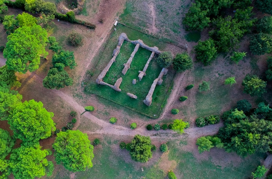
The integration of drone technology into archaeology has revolutionized the way researchers explore, document, and analyze historical sites. Drones, or unmanned aerial vehicles (UAVs), have emerged as powerful tools that provide archaeologists with unprecedented aerial perspectives and data collection capabilities. This technological advancement has not only enhanced the efficiency of archaeological surveys but has also opened new avenues for understanding and interpreting ancient landscapes.
As the field of archaeology continues to evolve, the adoption of drones signifies a shift towards more innovative methodologies that leverage modern technology to uncover the past. The use of drones in archaeology is not merely a trend; it represents a fundamental change in how archaeologists approach their work. Traditionally, site mapping and documentation required extensive ground surveys, which could be time-consuming and labor-intensive.
However, with the advent of drone technology, researchers can now capture high-resolution images and create detailed topographical maps in a fraction of the time. This capability allows for a more comprehensive analysis of archaeological sites, enabling scholars to identify features that may have gone unnoticed in conventional surveys. As drones become increasingly accessible and affordable, their application in archaeology is likely to expand, further enriching our understanding of human history.
Key Takeaways
- Drones have revolutionized the field of archaeology by providing a new and efficient way to map and study archaeological sites.
- Using drones for site mapping offers benefits such as cost-effectiveness, time efficiency, and the ability to access hard-to-reach areas.
- Drones improve accuracy and efficiency in mapping by capturing high-resolution images and creating detailed 3D models of archaeological sites.
- Successful examples of drone mapping in archaeology include the discovery of hidden structures and the documentation of large-scale sites with precision.
- Drones play a crucial role in preserving and protecting archaeological sites by providing valuable data for conservation and management efforts.
The Benefits of Using Drones for Site Mapping
One of the most significant advantages of employing drones for site mapping is the ability to cover large areas quickly and efficiently. Traditional mapping methods often involve extensive fieldwork, which can be hindered by challenging terrain or environmental conditions. Drones can easily navigate these obstacles, capturing aerial imagery from various angles and altitudes.
This capability not only accelerates the data collection process but also allows archaeologists to gather information from remote or difficult-to-access locations that would otherwise be challenging to survey. Moreover, drones equipped with advanced imaging technology can produce high-resolution photographs and 3D models that provide a wealth of information about archaeological sites.
The ability to create detailed topographical maps enhances the understanding of site layout and spatial relationships between different features. This level of detail is invaluable for researchers seeking to reconstruct past human activities and interactions with their environment.
How Drones Improve Accuracy and Efficiency in Mapping

Drones significantly enhance the accuracy of archaeological mapping through the use of photogrammetry and LiDAR (Light Detection and Ranging) technology. Photogrammetry involves capturing overlapping images from multiple angles, which are then processed to create precise 3D models of the terrain. This method allows for accurate measurements of distances, elevations, and volumes, providing archaeologists with reliable data for analysis.
The precision achieved through drone mapping surpasses that of traditional methods, reducing the margin for error in site documentation. In addition to improving accuracy, drones also streamline the mapping process, allowing archaeologists to focus on analysis rather than data collection. The automation of flight paths and data capture means that researchers can deploy drones to gather information while they attend to other aspects of their work.
This efficiency is particularly beneficial during large-scale excavations or surveys where time is of the essence. By minimizing the time spent on manual mapping, archaeologists can allocate more resources to interpretation and research, ultimately leading to more informed conclusions about the sites they study.
Examples of Successful Drone Mapping in Archaeology
Numerous archaeological projects around the world have successfully utilized drone technology to enhance site mapping and analysis. One notable example is the use of drones at the ancient Maya city of Tikal in Guatemala. Researchers employed UAVs to capture high-resolution aerial imagery of the site, revealing previously undocumented structures hidden beneath dense vegetation.
The resulting data allowed archaeologists to create detailed maps that highlighted the extent of urban development in Tikal, providing insights into the city’s growth and decline over centuries. Another compelling case is found in the archaeological investigations at Stonehenge in England. Drones were deployed to conduct aerial surveys of the surrounding landscape, uncovering a network of ancient monuments and earthworks that had remained largely unrecognized.
The high-resolution imagery captured by drones enabled researchers to analyze the spatial relationships between these features, shedding light on the cultural significance of the area during prehistoric times. Such discoveries underscore the potential of drone technology to reveal new dimensions of understanding in well-studied archaeological contexts.
The Role of Drones in Preserving and Protecting Archaeological Sites
Drones play a crucial role in the preservation and protection of archaeological sites by facilitating monitoring and documentation efforts. Regular aerial surveys using drones can help identify changes in site conditions over time, such as erosion, vegetation growth, or human encroachment. By maintaining an up-to-date record of site conditions, archaeologists can implement timely conservation measures to mitigate potential threats.
This proactive approach is essential for safeguarding vulnerable sites from degradation or destruction. Furthermore, drones can assist in creating digital archives of archaeological sites that can be shared with researchers, educators, and the public. These digital records serve as valuable resources for future studies and can help raise awareness about the importance of preserving cultural heritage.
By making high-quality imagery and 3D models accessible online, archaeologists can engage a broader audience in discussions about heritage conservation and the significance of archaeological research.
Challenges and Limitations of Using Drones for Site Mapping

Despite their many advantages, the use of drones in archaeology is not without challenges and limitations. One significant concern is regulatory compliance; many countries have strict regulations governing drone flights, particularly in sensitive areas such as archaeological sites. Obtaining necessary permits can be a time-consuming process that may delay research projects.
Additionally, operators must be trained to fly drones safely and effectively, which requires investment in education and resources. Another limitation is related to data processing and analysis. While drones can capture vast amounts of data quickly, processing this information into usable formats can be complex and resource-intensive.
Archaeologists may require specialized software and technical expertise to analyze drone-collected data effectively. Furthermore, there may be limitations regarding battery life and flight duration, which can restrict the extent of data collection during a single flight. These challenges necessitate careful planning and consideration when integrating drone technology into archaeological research.
Future Opportunities and Advancements in Drone Technology for Archaeology
The future of drone technology in archaeology holds exciting possibilities as advancements continue to emerge. One area ripe for development is the integration of artificial intelligence (AI) into drone operations. AI algorithms could enhance image processing capabilities by automating feature recognition and analysis, allowing archaeologists to identify significant patterns or anomalies within large datasets more efficiently.
This could lead to quicker insights into site characteristics and facilitate more informed decision-making regarding excavation or conservation efforts. Additionally, advancements in drone design are likely to improve their functionality for archaeological applications. Innovations such as longer battery life, improved sensors, and enhanced stability will enable drones to operate more effectively in challenging environments or over extended periods.
The potential for hybrid drones that combine multiple sensing technologies—such as thermal imaging or multispectral cameras—could further expand their utility in archaeological research by providing diverse datasets for analysis.
The Impact of Drones on Archaeological Site Mapping
The impact of drones on archaeological site mapping is profound and multifaceted. By enhancing efficiency, accuracy, and accessibility in data collection, drones have transformed traditional methodologies and opened new avenues for exploration within the field.
The ongoing evolution of drone technology promises even greater advancements in archaeological research methodologies. As challenges are addressed and new opportunities arise, it is clear that drones will play an increasingly vital role in shaping our understanding of past civilizations and their interactions with the environment. The future holds great potential for further integrating drone technology into archaeological practices, ensuring that our exploration of history remains dynamic and innovative.
Drones have revolutionized the way archaeological sites are mapped, providing researchers with detailed aerial views that were previously impossible to obtain. In a related article, Best Software for Furniture Design, explores how technology is also transforming the field of furniture design. Just as drones are aiding in archaeological site mapping, software tools are helping furniture designers create innovative and functional pieces with greater ease and precision. Both fields benefit from advancements in technology that enhance their respective practices.
FAQs
What are drones?
Drones, also known as unmanned aerial vehicles (UAVs), are aircraft that are operated without a human pilot on board. They can be controlled remotely by a human operator or autonomously by onboard computers.
How are drones used in archaeological site mapping?
Drones are used in archaeological site mapping to capture high-resolution aerial imagery of archaeological sites. This imagery can then be used to create detailed maps and 3D models of the sites, providing valuable information for archaeological research and preservation efforts.
What are the benefits of using drones for archaeological site mapping?
Using drones for archaeological site mapping allows researchers to quickly and efficiently capture detailed aerial imagery of sites that may be difficult to access on the ground. Drones can also cover large areas in a relatively short amount of time, making them a cost-effective and time-saving tool for archaeological research.
What types of drones are used for archaeological site mapping?
A variety of drones can be used for archaeological site mapping, including fixed-wing drones, multirotor drones, and hybrid drones. The choice of drone depends on factors such as the size and terrain of the archaeological site, as well as the specific requirements of the mapping project.
Are there any limitations to using drones for archaeological site mapping?
While drones offer many benefits for archaeological site mapping, there are also limitations to consider. Factors such as weather conditions, airspace regulations, and technical limitations of the drones themselves can impact their effectiveness in mapping archaeological sites. Additionally, drones require skilled operators and careful planning to ensure accurate and useful data collection.