The advent of artificial intelligence (AI) has revolutionized numerous fields, and remote sensing is no exception. Remote sensing, the acquisition of information about an object or phenomenon without making physical contact, has traditionally relied on satellite imagery and aerial photography. However, the integration of AI technologies into this domain has significantly enhanced the capabilities of remote sensing systems.
By leveraging machine learning algorithms and advanced data analytics, researchers and environmentalists can now process vast amounts of data with unprecedented speed and accuracy. This transformation allows for more effective monitoring of natural resources, ecosystems, and environmental changes. AI-driven remote sensing employs sophisticated algorithms to analyze data collected from various sources, including satellites, drones, and ground-based sensors.
These algorithms can identify patterns, detect anomalies, and predict future trends based on historical data. For instance, deep learning techniques can be utilized to classify land cover types or assess vegetation health by analyzing multispectral images. The ability to automate these processes not only saves time but also reduces human error, leading to more reliable outcomes.
As a result, AI-driven remote sensing is becoming an indispensable tool for scientists, policymakers, and conservationists striving to understand and protect our planet.
Key Takeaways
- AI-driven remote sensing is revolutionizing the way we monitor and manage ecosystems, combat deforestation, and protect wildlife.
- It plays a crucial role in tracking and combatting deforestation by providing real-time data and analysis to support conservation efforts.
- AI-driven remote sensing is essential for wildlife conservation and protection, helping to monitor and safeguard endangered species and their habitats.
- It is a powerful tool for assessing the environmental impact of climate change and improving agricultural practices for sustainable land management.
- In disaster management and response, AI-driven remote sensing provides valuable insights for early warning systems and rapid assessment of affected areas, but also presents challenges for data interpretation and privacy concerns.
Monitoring and Managing Ecosystems
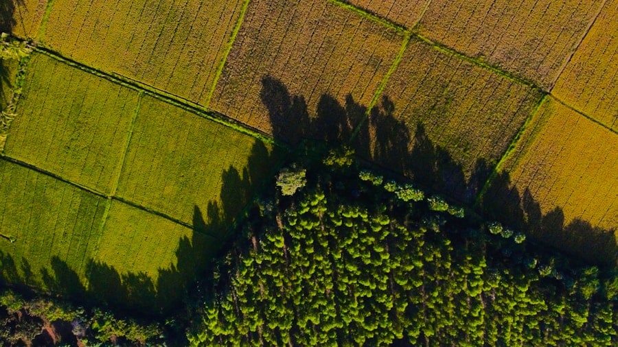
Ecosystem monitoring is crucial for maintaining biodiversity and ensuring the sustainability of natural resources. AI-driven remote sensing technologies facilitate the continuous observation of ecosystems, enabling researchers to gather real-time data on various environmental parameters. For example, satellite imagery combined with AI algorithms can track changes in land use, vegetation cover, and water bodies over time.
This information is vital for understanding ecosystem dynamics and assessing the impacts of human activities such as urbanization and agriculture. Moreover, AI can enhance the management of ecosystems by providing insights into their health and resilience. By analyzing data from multiple sources, including climate models and ecological surveys, AI systems can identify stressors affecting ecosystems and predict their responses to environmental changes.
For instance, machine learning models can analyze historical data on temperature and precipitation patterns to forecast how a particular ecosystem might respond to future climate scenarios. This predictive capability allows for proactive management strategies that can mitigate potential threats to biodiversity and ecosystem services.
Tracking and Combatting Deforestation

Deforestation poses a significant threat to global biodiversity and contributes to climate change by releasing stored carbon dioxide into the atmosphere. AI-driven remote sensing plays a pivotal role in tracking deforestation activities and developing strategies to combat them. High-resolution satellite imagery can be analyzed using machine learning algorithms to detect changes in forest cover with remarkable precision.
These algorithms can differentiate between healthy forests, degraded areas, and completely deforested regions, providing critical data for conservation efforts. In addition to monitoring deforestation, AI technologies can also support reforestation initiatives. By identifying areas that are suitable for reforestation based on ecological criteria such as soil type, climate conditions, and existing biodiversity, AI can help prioritize restoration efforts.
For example, organizations like Global Forest Watch utilize AI to provide real-time alerts about illegal logging activities, enabling timely interventions by authorities. This combination of monitoring and actionable insights empowers stakeholders to take informed steps toward preserving forest ecosystems.
Wildlife Conservation and Protection
Wildlife conservation is another area where AI-driven remote sensing has made significant strides. The ability to monitor animal populations and their habitats from space or through aerial surveys has transformed conservation strategies. AI algorithms can analyze images captured by drones or satellites to identify wildlife species, track their movements, and assess habitat quality.
This information is crucial for understanding population dynamics and implementing effective conservation measures. For instance, researchers have employed AI to monitor endangered species such as elephants and rhinos in their natural habitats. By analyzing thermal imagery or high-resolution photographs, AI systems can detect the presence of these animals even in dense vegetation.
Furthermore, machine learning models can predict animal behavior based on environmental factors, helping conservationists anticipate potential threats such as poaching or habitat loss. The integration of AI into wildlife conservation efforts not only enhances data collection but also enables more targeted interventions that can significantly improve species survival rates.
Climate Change and Environmental Impact Assessment
Climate change is one of the most pressing challenges facing humanity today, necessitating comprehensive monitoring and assessment of its impacts on the environment. AI-driven remote sensing provides valuable tools for evaluating climate change effects on various ecosystems and natural resources. By analyzing long-term satellite data, researchers can identify trends in temperature changes, sea-level rise, and extreme weather events.
This information is essential for understanding the broader implications of climate change on biodiversity and ecosystem services. Moreover, AI technologies facilitate environmental impact assessments (EIAs) by automating the analysis of large datasets related to proposed projects or policies. For example, when assessing the potential impacts of a new infrastructure project on local ecosystems, AI can quickly analyze satellite imagery to evaluate land use changes and habitat fragmentation.
As a result, AI-driven remote sensing is becoming an integral part of sustainable development planning.
Improving Agricultural Practices

Agriculture is a sector that stands to benefit immensely from AI-driven remote sensing technologies. Precision agriculture relies on accurate data to optimize crop yields while minimizing resource use. Remote sensing provides farmers with critical information about soil health, moisture levels, and crop conditions through satellite imagery and aerial surveys.
By integrating AI algorithms into this data analysis process, farmers can make informed decisions about irrigation, fertilization, and pest management. For instance, machine learning models can analyze multispectral images to assess crop health by detecting variations in plant color and vigor. This information allows farmers to identify areas that require attention before problems escalate into larger issues.
Additionally, AI can predict crop yields based on historical data and current environmental conditions, enabling farmers to plan their operations more effectively. The combination of remote sensing and AI not only enhances agricultural productivity but also promotes sustainable practices that reduce environmental impacts.
Disaster Management and Response
Natural disasters pose significant risks to communities worldwide, necessitating effective management strategies for preparedness and response. AI-driven remote sensing technologies play a crucial role in disaster management by providing timely information about impending threats such as hurricanes, floods, or wildfires. Satellite imagery can be analyzed in real-time to assess damage extent and inform emergency response efforts.
For example, during a hurricane event, AI algorithms can process satellite images to identify areas most affected by flooding or wind damage. This information enables emergency responders to allocate resources efficiently and prioritize rescue operations in high-risk zones. Furthermore, machine learning models can analyze historical disaster data to improve predictive capabilities for future events.
By understanding patterns in past disasters, authorities can develop more effective mitigation strategies that enhance community resilience.
Future Implications and Challenges
As AI-driven remote sensing continues to evolve, it presents both exciting opportunities and significant challenges for environmental monitoring and management. The potential for improved accuracy in data collection and analysis could lead to more effective conservation strategies and sustainable resource management practices. However, the reliance on technology also raises concerns about data privacy, ethical considerations in surveillance, and the digital divide between developed and developing regions.
Moreover, the integration of AI into remote sensing requires substantial investment in infrastructure and training for personnel who will operate these advanced systems.
As we look toward the future, it will be essential to address these challenges while harnessing the power of AI-driven remote sensing to create a more sustainable world for generations to come.
A related article discussing the best tablets for business in 2023 can be found here. This article provides insights into the top tablets that are ideal for professionals looking to enhance their productivity and efficiency in the workplace. Just like how AI-driven remote sensing is revolutionizing environmental conservation efforts, having the right technology tools, such as tablets, can greatly improve business operations and decision-making processes.
FAQs
What is AI-driven remote sensing?
AI-driven remote sensing refers to the use of artificial intelligence (AI) to analyze data collected from remote sensing technologies such as satellites, drones, and sensors. This technology allows for the automated analysis of large amounts of environmental data to monitor and manage natural resources and ecosystems.
How is AI-driven remote sensing used in environmental conservation?
AI-driven remote sensing is used in environmental conservation to monitor and manage natural resources and ecosystems. It can be used to track changes in land use, deforestation, wildlife populations, and environmental pollution. This technology enables more efficient and accurate monitoring of environmental changes, allowing for better-informed conservation efforts.
What are the benefits of AI-driven remote sensing in environmental conservation?
The benefits of AI-driven remote sensing in environmental conservation include improved monitoring and management of natural resources, more efficient data analysis, and the ability to detect environmental changes in real-time. This technology also allows for the identification of conservation priorities and the development of targeted conservation strategies.
What are some examples of AI-driven remote sensing applications in environmental conservation?
Some examples of AI-driven remote sensing applications in environmental conservation include monitoring deforestation and illegal logging, tracking wildlife populations and migration patterns, assessing the impact of climate change on ecosystems, and detecting environmental pollution. These applications help conservationists and policymakers make informed decisions to protect and preserve the environment.
What are the challenges of using AI-driven remote sensing in environmental conservation?
Challenges of using AI-driven remote sensing in environmental conservation include the need for high-quality and reliable data, the complexity of analyzing large datasets, and the integration of AI technology with existing conservation practices. Additionally, there may be ethical and privacy considerations when using remote sensing technologies for environmental monitoring.